Background
Cooperative Systems are defined in order to allow bidirectional communication between vehicles, and between vehicles and infrastructure, in order to improve the information shared between road actors and improving the safety, traffic information, comfort and situation awareness, by increasing significantly road safety, traffic efficiency, and reducing the number of accidents aa well as providing a more reliable infrastructure to the different drivers.
Thinking about the mid and long term, cooperative systems will also support connected and automated vehicles to extend their perception field, and therefore helping autonomous vehicles to take the right decisions beforehand.
ITS Center is a web platform developed by CTAG responding to the need of managing the Cooperative ecosystem as a whole.
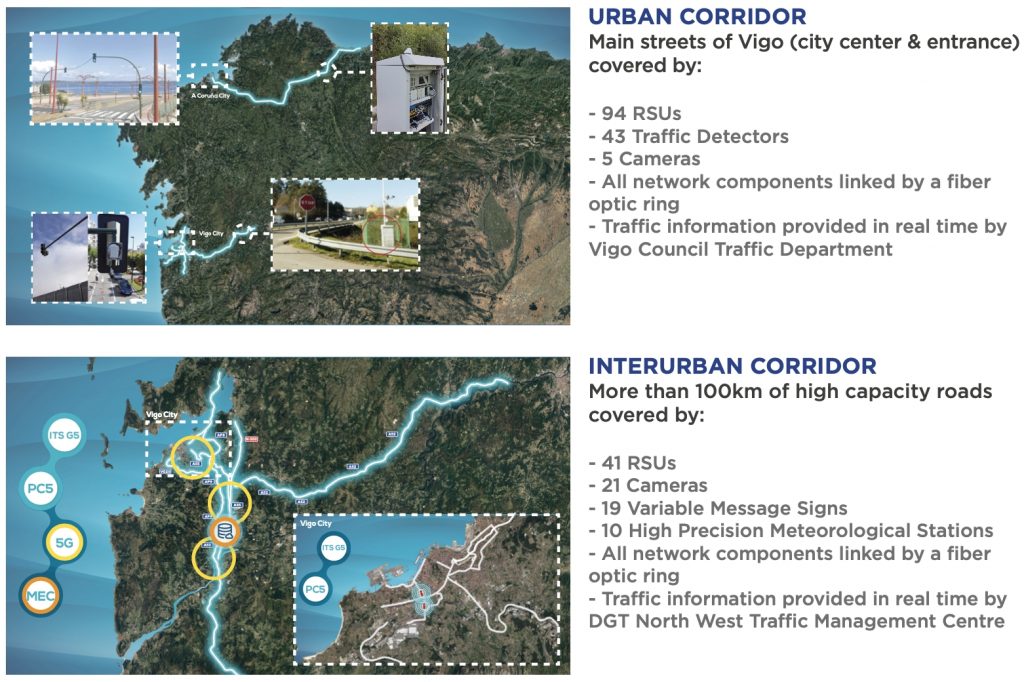
SISCOGA corridor
In this way, the ITS Center allows the management of the more than 100 kilometers urban and interurban roads that are equipped with CTAG more tha 100 RSUs and decens of cameras, as well as the main streets in Vigo and in Porriño which are publishing trafficlights information to the C-ITS Center in real-time. All of that together compound what is known as SISCOGA corridor:
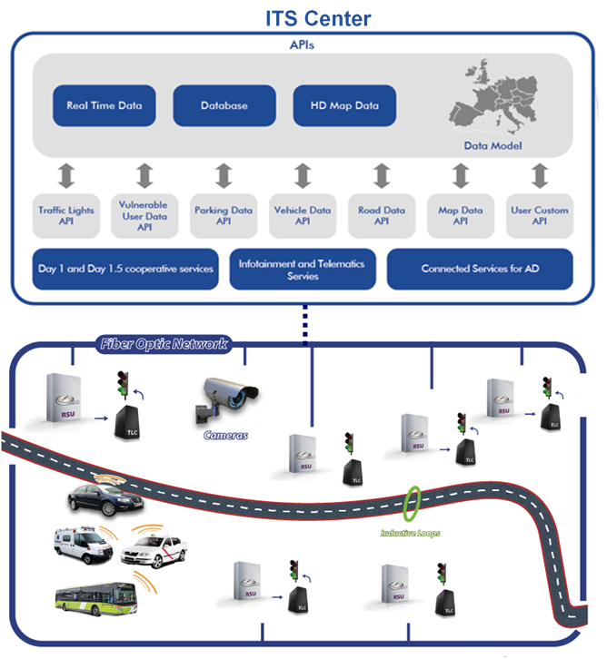
ITS Center overview
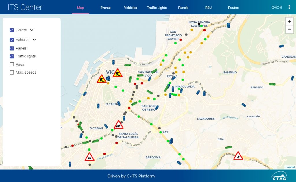
The ITS Center allows the management, monitoring and actuation of the different cooperative elements. Thus, the infrastructure manager can visualize the status of the different RSUs, OBUs, traffic events, alerts, etc. and perform different actions to add, modify or delete all the information displayed at any time.
ITS Center also allows the connection with other data sources (including Datex II) increasing the possibilities of information sharing and completing a standardized solution.
Some of the main functionalities are described below:
RSU and OBU management
ITS Center presents in real time several parameters of the existing Road Side Units and OnBoard Units:
- Location: For the RSUs will be fixed, and variable for the OBUS
- Status: ON, ON and ACTIVE, ON with ERRORS, OFF, etc.
- Errors
- Info related only to OBUs
- Speed
- Vehicle fuel status
- Other relevant vehicle information that can be defined
- Info related to device software version, and its updates:
- Current software version
- Remote software update (SOTA): For a specific RSU, or for all the RSUs that belong to the TMC network.
- Remote reboot and system restart
- Cooperative events and messages management
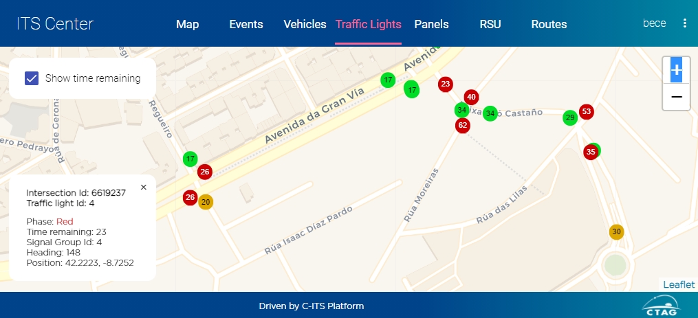
Traffic Lights management
ITS Center represents in the status of the traffic lights within the intersections registered. It is possible to visualize in real-time the current phase and its time remaining to change of each traffic light with only one click.
Alerts
Traffic management users will be able to set alerts in order to inform different malfunctions or undesired behaviours, for example, a RSU that does not response after a defined amount of time, or an unexpected weather condition.
Cooperative services information management
ITS Center will allow the complete management of the cooperative events and messages that will feed the different cooperative services.
In this way, events can be added, modified or removed, according to the needs. Also, external data sources will be able to be added in order to get information from other entities or authorities, and based on the Datex II standard.
Day 1 services
This is a list of the Day 1 services available that are already included and deployed:
- Slow or stationary vehicle(s)
- Traffic jam ahead warning
- Road works warning
- Accident
- Hazard: obstacle
- Hazard: animals
- Hazard: person, people
- Weather: strong wind
- Weather: visibility
- Weather: precipitations
- Weather: surface adhesion
- Hazard: road surface
- Dangerous situation
- In-vehicle signage
- In-vehicle speed limits
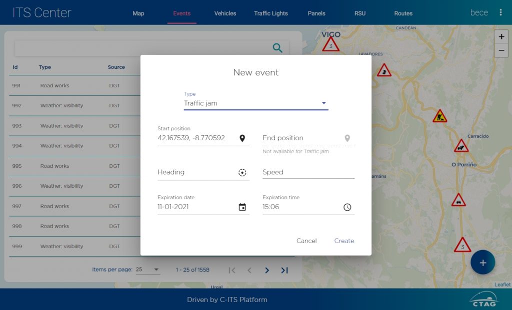
Traffic warning and alerts mentioned above, can be created, not only by gathering the information from different traffic information APIs, corresponding to traffic authorities or other information providers, but also created manually from the ITS Center manager interface.
Some of those warning, such as accidents, traffic jams, weather (visibility, precipitation, …) can be created as well by the PVD service which algorithms analyze the information published by the connected vehicles (speed, location, lights and wipers CAN status, etc, …)
In order to increase the available data for the cooperative services, different information can be included in the ITS Center, for example, the fuel and charging station can be added (location, pricing, quality, etc.), speed limits, etc.
In this way, the platform is open and flexible to add new functionalities that could be required in the future.
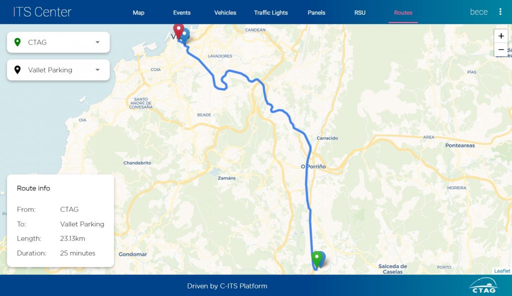
Routes calculation
ITS Center allows queries in order to calculate the list of nodes that are necessary to perform a route by autonomous vehicle prototypes.
The route calculator will select the best route based on the current traffic status by crossing the available routes options with the current ITS information.