Road Hazard Warning (RHW)
The objective of Road Hazard Warning is to provide timely in-vehicle driving assistance information on hazardous locations downstream of the current position and in the driving direction of the vehicle.
Taking into account various stakeholders’ views, a list of business model blueprints that address current or future challenges of urban areas, together with their operating and value-capture scenarios depicting the inner-workings of the business models, and the exchange of costs-benefits among stakeholders, have been created for the Road Hazard Warning service.
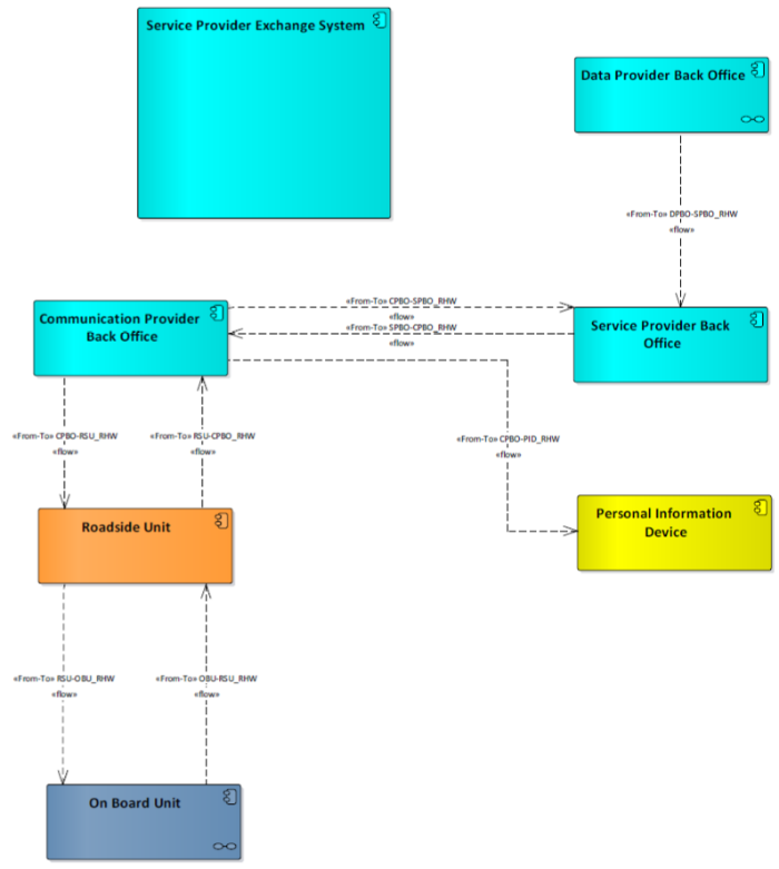
Detailed information about Road Hazard Warning architecture can be found here.

Within the C-MobILE project the Road Hazard Warning service is implemented in all eight Deployment Sites: Barcelona, Bilbao, Bordeaux, Copenhagen, Newcastle, North Brabant, Thessaloniki, and Vigo.
In Barcelona the Road Hazard Warning service is based on cellular communication technology. This service covers the entire city, including its main access roads, providing real-time information about different hazards (such as congestions, accidents, vehicle breakdowns, weather conditions, etc.) and their location. Applus IDIADA is the service provider receiving the information from the mobility databases of the City Council, Servei Català de Trànsit and RACC and providing it to the drivers through an App.
In Bilbao the Road Hazard Warning service is implemented using cellular communication technology. The service is available in the urban road network. CEIT is the service provider cooperating with Bilbao OpenData Platform and Traffic Management Centre for road hazard data provisioning. NeoGLS is the App provider for this service providing users with real time information.
In Bordeaux the Road Hazard Warning service is implemented using both cellular and ITS-G5 communication technologies. The road hazard information comes from both the “Bison Futé” database named “TIPI” (providing road hazards information on highways and inter-urban roads). It provides information about vehicle breakdowns, accidents, degraded roads, closed roads, etc. The service provider for RHW is NeoGLS and the service is available through the App “CTD – Connected Mobility”.
In Copenhagen the Road Hazard Warning service is implemented using cellular communication technology. The service covers the entire city road network providing drivers with an Icy Roads Warning when the road temperature is close or below the freezing point. Road temperature measurement data are published to the Danish National Access Point (https://nap.vd.dk/). From this database information is acquired and published by the local Geo-Messaging server according to the appropriate standards to allow service providers and App developers to provide the information to their users.
In Newcastle the Road Hazard Warning service is implemented using cellular communication technology. The data comes from a database of events managed and operated by the Tyne and Wear UTMC. This data is converted to DENM messaging by Zircon and Siemens and delivered in real time for users of the CTD App developed by NeoGLS. This service is available across the Tyne and Wear region, and also on highways England roads across the whole north east region of England.
In North Brabant the Road Hazard Warning service is implemented using both cellular and ITS-G5 communication technologies. This service is currently tested on the highway.
In Thessaloniki the Road Hazard Warning service is based on cellular communication technology. The service covers a wide area of the city road network including urban and inter-urban areas. The service provider, the Hellenic Institute of Transport (CERTH-HIT), cooperates with the Traffic Management Centre of Thessaloniki (by the Region of Central Macedonia) for data exchange and information provision to drivers through the CERTH-HIT App (cmobile.imet.gr).
In Vigo the Road Hazards Warning service is implemented using cellular communication technology. This service provides information related to existing hazardous events in a wide area of the city road network including urban and inter-urban areas, the latter belonging to the corridor SISCOGA4CCAM.
CTAG is the service provider managing traffic information gathered from the Traffic Management Centre of Vigo and the Spanish Traffic Directorate (DGT) and distributing it in real time to drivers through CTAG GeoServer using the local App.